Visible shipwrecks: the barge Margaret

One of the most spectacular shipwrecks I’ve ever seen was that of the 100 metre long unmanned barge Margaret, which ran aground at Jacobsbaai on the West Coast on 24 June 2009. Margaret was carrying two halves of a floating dry dock and twelve river barges (positioned atop each other in side by side pairs, with two rows of three at the bottom). She was under tow by the tug Salvaliant from the Chinese shipyard where everything was manufactured, to Rotterdam. The barges were destined to transport cargo up and down the navigable rivers in Europe. During a winter storm, the tow parted, and Margaret and her cargo ran hard aground on the rocky reef just outside Jacobsbaai.

The eight storey pile of barges in December 2009

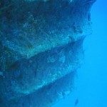
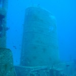
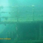
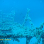
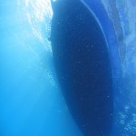
Salvaging the barges proved to be an almost intractable problem, so Margaret was still sitting firmly a couple of hundred metres off the beach when Tony and I visited six months after her grounding, in late December 2009. The stack of barges and two halves of a floating dry dock (the blue parts of the structure in the images) was clearly visible from a great distance. The sight was even more incongruous than that of the Eihatsu Maru aground on Clifton beach, which was  a wreck-lover’s dream (but unfortunately not a permanent arrangement).

View of the barge Margaret from atop the sand dunes at Jacobsbaai

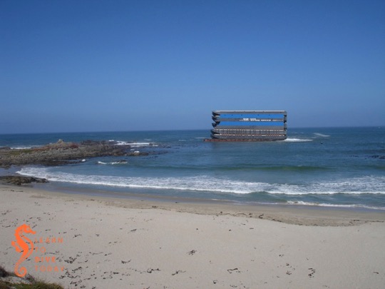
I wish I’d taken a picture of what the wreck looked like as we drove down the hill into Jacobsbaai, but you can see one here if you scroll around a bit. It looked like an office block rising out of the ocean. The wreck was so large that it was visible from almost every point in the sleepy town, and the brain struggled to make sense of the sight. It’s clear from the images what a challenge it must have been to tow the barge in the wind, as the forty to fifty metre high, perfectly flat sides of the stack must have provided tremendous resistance in a gale.

Portion of the barge wreck at Jacobsbaai

The owner ran out of money to continue salvage in February 2010, and Margaret was becoming increasingly damaged and unstable as time passed. The risk of the upper barges coming loose during another storm, and drifting away to cause a hazard to other ships or coming ashore on the beach, was great. It was decided by SAMSA to persist with an attempt to reduce the wreck, at taxpayers’ expense. Any money obtained by selling off the salvageable barges would go towards defraying costs.

During the salvage work on the barge Margaret

Salvage

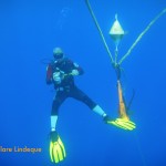
Tony and I visited the wreck again in April 2010, after the demolition that freed six of the topmost barges. The seaward wall of the upper piece of floating dry dock, weighing 91 tonnes, had been cut away to allow the barges to slide off freely.

The remains of the barge Margaret in April 2010

Over two tons of explosives were used in total.  Small (125 kilogram) explosive charges were set off one after the other to create a ripple effect that dislodged the top six barges. These were towed to Saldanha, and then sold.

The wreckage of Margaret and her cargo in April 2010

If you like reading court judgments, here’s one in which the owners of the barges attempt to claim damages (massive ones) from the owners of the tug Salvaliant. There’s also a great collection of photos of the wreck in her various incarnations here.

The wreckage of Margaret in late April 2010

In late April 2012, Tony snapped this lucky shot of two of the barges leaving Simons Town harbour under tow. They’d been moored against the harbour wall for at least a month, to the consternation and fascination of the local paddling community.

Two of the salvaged barges leaving Simons Town harbour in April 2012

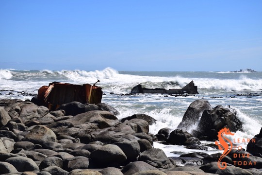
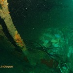
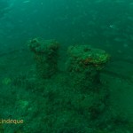
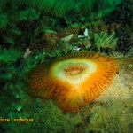
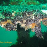
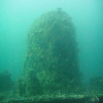
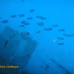
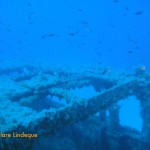
The remains of Margaret and her cargo were further demolished down to sea level and below, and now comprise an artificial reef. Fortunately there was no fuel or other pollutants in the stack of barges, which made the process significantly less polluting than it might otherwise have been.

The barge Margaret today

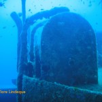
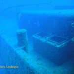
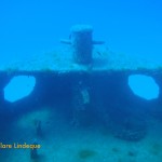
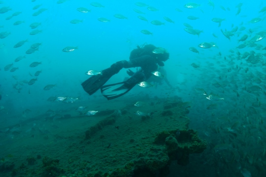
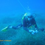
Tony and I visited Jacobsbaai to check out what remains of Margaret and her cargo in September 2018. The path to the wreck, which was formerly blocked off by hazard tape and “salvage in progress” signs, is wide and easily walkable. One can go right up to the rocks and view the wreckage from reasonably close up. Watch your foothold here, as it can be slippery and the rocks aren’t all firmly packed.

The remains of the barge Margaret and her cargo

Look out for a small memorial to one of the salvors, who passed away in an accident on the wreck during the course of the salvage operation.

Sharp wreckage sticking out of the sea

Parts of the wreck look like shark fins in the water, and it is possible that even more of it is visible at low tide.

The remains of the barge Margaret in 2018

You can find the wreck by turning off the R399 towards Jacobsbaai, and continuing towards the coast until the road becomes gravel. Carry on this road, and when you reach a T junction take a right turn to circle around the tiny, sheltered bay in front of you. When you can’t drive any more – there will be a small housing development in front of you – park the car and either walk up the steps on the dune to get onto the beach, or, preferably, through the houses. The paved area will give way to a wide gravel path that the salvors used to access the wreck. Continue straight along it and you’ll soon spot the wreckage on the rocks ahead and to your right. Co-ordinates are approximately -32.964140, 17.881612.

Path to what remains of the barge Margaret

If you’re interested in visible shipwrecks, check out my ebook Cape Town’s Visible Shipwrecks, and this post.

Dive sites (Durban): Fontao

The bow of the Fontao

The Fontao is an old Mozambican prawn trawler, scuttled off Umhlanga in Durban by the Oceanographic Research Institute in 1991. The intention was to study the rate at which wrecks and artificial reefs are colonised by marine organisms. The wreck is small: just under 35 metres long, with a beam of 8 metres. She lies upright on the sand at about 27 metres’ depth, and is largely intact. Tony did an eventful wreck penetration dive here during some of his training at Calypso… Ask him about it!

While waiting for the skipper and Divemaster to hook the anchor to the wreck (common practice in Durban), we were able to socialise with a couple of Indian yellow nosed albatross. These rare birds have incredibly impressive wingspans, and also came to visit us on several subsequent dives hoping we’d brought snacks.

Descending onto the wreck we were greeted with dense clouds of piggies, silvery baitfish that hang around above the wreck and parted gently to allow us to swim through. The wreck is covered with lead sinkers and fishing line, and is a popular fishing destination. Just inside part of the superstructure is a memorial plaque dedicated to a diver (now deceased) who specially enjoyed this dive site.

There is a mosaic floor – apparently prawn trawlers were festive places – and the bow is very beautiful, but because of all the fish it was hard to get a good look at the wreck as a whole (not complaining)! When we dived the Fontao there was a strong current across the wreck, which made me reluctant to stray too far from it lest I got swept off onto the sand.

We dived on air and had a decent-length dive because we spent most of our time on the top of the wreck, which is at about 18 metres. For exploring the bottom and sides of the hull further, Nitrox/enriched air would be a help.

Swimming through piggies on the wreck of the Fontao

Dive date: 18 June 2013

Air temperature: 23 degrees

Water temperature:  22 degrees

Maximum depth:  27.2 metres

Visibility: 15 metres

Dive duration: 40 minutes

Article: Outside on tiger sharks in Hawaii

Hawaii is one of the places on earth where an enlightened government is working for mutual safety of the local shark population, and the surfers, swimmers and other water users who occasionally happen upon sharks in their natural habitat. Like our local Shark Spotters program, non-lethal methods are used to manage the chance of human-shark interactions.

Starting in the 1950s, the Hawaiian government killed thousands of sharks as part of a culling program, believing that sharks were territorial and that eliminating a shark seen near a beach would be removing it from its residence, making the beach safer.

Carl Meyer of the University of Hawaii was part of research begun in the 1990s that tracked tiger sharks with hydrophones. Researchers saw immediately that the sharks were not resident in one location but, much as great white sharks do, they range widely. As a response to the very first tracking study, the state of Hawaii stopped hunting sharks after they had bitten humans, as the evidence indicated that the responsible shark would be long gone before a “cull” could be instituted. Meyer says in an interview with Outside Online:

So clearly, there were two broad lines of evidence that this shark control stuff was worthless. One was critical tracking data showing that these sharks were much more mobile than people believed. The second was that people were still getting bitten at sites from which many tiger sharks had already been removed by control fishing. So there’s just no evidence that shark culling makes the water safer. It’s just not demonstrably effective.

Both Western Australia and Reunion Island (a French territory in the Indian Ocean) have decided recently to hunt sharks after fatal interactions with humans. Meyer explains why localised spikes in shark bites occur, dismissing many of the (understandable) conclusions that people rush to without recognising the inherent variability of natural systems (emphasis mine):

What you tend to have is a typically low number of shark attacks, and over time you might see some spikes in the number of bites. It doesn’t mean there’s any fundamental change in marine ecosystems. It doesn’t mean, for example, that a bunch of sharks have moved into your area. It might be nothing more than natural variability, which occurs in marine or terrestrial systems. Nature is an inherently noisy system. Part of the noise is variation in stuff, including the number of people that get bitten by sharks.

Meyer also discusses the behaviour of sharks around fish farms: they seem to be attracted to the net structures out at sea, although they do not seem to actually eat the fish in the farms. He suggests that the large three dimensional structures of the farms, alone in a vast and featureless oceanscape, are interesting in the same way that a shipwreck or other artificial reef is to a fish. I found this fascinating, but it is not a completely outlandish idea that a creature as intelligent as a shark would perhaps derive visual stimulation from something like a fish farm. He also theorises that they could be good meeting places to hook up with other sharks!

Finally, he touches on the cage diving operations in Hawaii.

Another issue which has generated a lot of heat here in Hawaii and elsewhere is shark cage diving ecotourism. These activities have proven hugely controversial. We’ve done a fair bit of work on the one here on Oahu, including a meta analysis of logbook data and tracking long-term movements of sharks captured at the cage diving sites—the takeaway message is that there’s absolutely no scientific evidence whatsoever that the existing operations off Oahu are a threat to public safety, which has been people’s major concern.

The findings he reports are similar to those reported for False Bay’s white sharks.

Read the full interview here. It contains incredibly important information and principles. It explains how scientists think about animal behaviour, gather evidence, and draw conclusions. Even if you don’t follow any other link I give you this year, please follow this one. Do it!

Article: The Daily Maverick on floating utopias

Rebecca Davis of The Daily Maverick recounts a history of efforts to create floating utopias – independent “countries” that are moored or constructed in the world’s oceans. From The Principality of Sealand (I follow them on facebook), located on an old World War II sea fort in the North Sea, to various failed attempts to use artificial islands built atop reefs or derelict ships (much like Kevin Costner in Waterworld), these efforts to create independent, autonomous colonies apart from dry land have absorbed entrepreneurs and those with deep pockets for decades.

The latest effort, which might even be viable, is called Blueseed. The plan is to station a vessel 12 nautical miles off the coast of California, where foreign techies, entrepreneurs and (I quote) “visionaries” can work and make occasional visits to the US on business/tourist visas. This is a work-around for the somewhat restrictive immigration laws of the US. The 12 nautical mile anchorage puts the vessel in international waters, outside the jurisdiction of the USA. The Top 10 Facts about BlueSeed gives a run-down of the motivation for the project and how it will work. In order to get aboard, you have to “do something that matters, and be awesome.” To me, it sounds as though their recruitment agent is Barney Stinson.

Read the full Daily Maverick article here.

Dive tourism in Malta (and some hints for South Africa)

Last year August, Tony and I spent a blissful week in Malta, diving ourselves silly in the mornings and napping in the heat of the afternoon. In the evenings, we ate ice cream and participated in the time-honoured Italian tradition of the passegiata.

Malta, Comino and Gozo from the air

The nation of Malta comprises three small islands located just south of Italy, in the Mediterranean Sea. The water is warm, there is almost no sand around the islands (most of the beaches are man-made), the limestone structure of the islands gives rise to caves, swim throughs and gullies to explore, and there is negligible tidal activity. The climate in summer is almost boringly warm and stable and with the exception of some violent winter storms, the ocean surrounding Malta is welcoming all year through. These factors combine to make it an extremely attractive location for scuba diving.

Malta’s natural charms, however, are greatly enhanced by her government’s approach to dive tourism. Recognising that visiting divers bring considerable income to all sectors of the Maltese economy (divers eat, need somewhere to sleep, and can’t spend all day diving!), the government has over the years scuttled a number of ships (ten or more at last count) as attractions for divers. These include the Um El Faroud, the Imperial Eagle, the P29, and the Rozi – all of which we dived. There are also a number of World War II wrecks (submarines!) around the islands, many at depths suitable for technical diving only.

Diving in Malta is well regulated. The Professional Diving Schools Association is a voluntary organisation representing over 30 dive centres in Malta, and encourages its members to adhere to high standards of safety and care. Divers visiting Malta are required to complete medical questionnaires before being allowed to dive, and are required to adhere to certain other regulations governing divers and their safety.

We very much enjoyed the wrecks in Malta, and found a special charm in even the newer ones that were scuttled in the last five years. The P29, for example, was almost clear of marine invertebrate growth, and all the wrecks were still discernible as the beautiful ships they once were. Surrounding them we found scores of fish – damselfish, barracuda, and the odd tuna.

There are several purposely-scuttled wrecks available around Cape Town, but there’s been no additional activity on this front for years. Only the Aster – the newest wreck, scuttled close to 20 years ago – still looks much like a ship. The Smitswinkel Bay wrecks – the Good Hope, Transvaal, Orotava, Princess Elizabeth and Rockeater, were scuttled over 30 years ago and have been pounded by the rough winter seas of the Cape. They are recognisable as ships, but penetrating any of them is a mug’s game and often during dives on these wrecks one can hear them creaking and groaning in the surge. The SAS Pietermaritzburg is in an even more exposed position off Miller’s Point, and is yet more beaten up despite being more recent than the Smitswinkel Bay wrecks.

Before I get shot down in flames for trying to compare Maltese and South African wrecks (age differences aside), let me qualify my statements. I recognise that there are significant differences between the Mediterranean Sea around Malta and the two oceans surrounding the South African coast – here are two:

  • the quantity of biomass that is supported off the Cape coast is far greater than that supported by the almost sterile (I exaggerate) waters of the Med – invertebrates quickly cover available surfaces and blur the outlines; and
  • the tides and currents around our coast are fierce and strong, and in a short time weaken any structure placed underwater.

What isn’t different, however, is how valuable scuba diving tourists are to the countries’ economies. Divers who have the means to travel and scuba dive also have the means to enjoy other activities in their destination countries. Diving is often a hobby of those who generally enjoy the outdoors, and a country like South Africa (as opposed to, say, Dubai) has a wealth of experiences in nature to offer such tourists.

Very little grows in Malta, and the islands are hilly but no one would travel there for that reason alone.  Compared to Malta, South Africa is ridiculously blessed with spectacular landscapes and wildlife both above and below the ocean. South African divers also know the tropical wonders of Sodwana, the chilly but exhilarating shark, wreck and reef diving available in the Cape, and the incredible ecosystems in between. This is all in addition to our mountains, deserts, fynbos, bush, and coastal scenery. Why isn’t more made of our underwater heritage?

It would be wonderful to see the South African government and South African National Parks being receptive to more properly cleaned wrecks being scuttled around our coast in locations suitable for recreational diving. More Marine Protected Areas, properly policed, would be good. It would also be great to see local dive centres striving to offer meaningful, repeatable diving experiences to tourists, instead of seeing them as once-off cash cows who can be taken out for a dive in appalling conditions because they aren’t coming back anyway. It would also induce much joy if airlines of all sizes in South Africa recognised (as Air Malta does) that scuba diving is a sport, like (ahem – sorry divers) golf, and gave an extra luggage allowance for scuba diving equipment.

I don’t think enough is done to encourage tourists to visit this country in order to dive, or with diving as one of their primary activities. It would benefit everyone – not just dive centres and dive charters – if more could be made of this opportunity. The example of Malta is a good one.

Dive sites: MV Aster

Tripod mast
Tripod mast

Tony has been alternately ragging and begging Grant for the last long while, wanting to dive the MV Aster in Hout Bay. He finally got his wish, along with me, Goot and Cecil, one magnificent weekend in early July. The sea was flat, the air was warm, and after an unseasonal week of southeasterly winds, the Atlantic was fairly clean.

The Sentinel outside Hout Bay harbour

The Aster is just outside Hout Bay harbour, fairly sheltered in the mouth of the bay. It was deliberately scuttled – by divers, for divers – in 1997. The ship was cleaned, the interior was stripped of wires and furnishings, and all doors and hatches were removed. Openings were cut into the hull of the ship, and it’s probably one of the most friendly wrecks to penetrate in Cape Town. When we dived it, Peter Southwood was venturing inside to check that his schemes of arrangement on the wikivoyage site are correct and current.

Peter Southwood's line stretches beneath a hatch in the deck
Peter Southwood’s line stretches beneath a hatch in the deck

The top of the wreck is at a depth of about 20 metres, and if you bury yourself in the sand under the ship you might get 28 metres or so. There’s a large tripod mast that extends to within 10-12 metres of the surface, and ascending next to this is a treat. The ship stands upright, alone on a sandy bottom, and the wreck of the Katsu Maru lies about 30 metres away over the sand. The Aster was a crayfishing vessel, and is about 36 metres long. There are gangways, ladders, winches, lots of superstructure, and even a railing at the bow if you want to play Titanic there (Tony did).

Reminds one of a scene from Titanic?

The Atlantic is nutrient-rich (effluent from the Disa River in Hout Bay probably also helps here) and the wreck is quite heavily encrusted. Tony observed that even though the Cedar Pride, a wreck he dived when living in Jordan, has been underwater longer than the Aster, she’s far less covered with marine life.

Hagfish on deck
Hagfish on deck

I found a hagfish sleeping on deck below the mast, and we were delighted by the many tiny West coast rock lobsters all over the wreck (some large ones too). We found a couple the size of shrimps – adorable (to my mind)! There’s a lot of invertebrate life to enjoy, but I didn’t find any nudibranchs despite looking. Many of the ones found on this wreck are of the “beige with brown spots” variety and having never seen one in real life, it’s going to take a while to train my eyes to find them!

Tiny West coast rock lobster in a mussel shell

The marine life is lovely, and can absorb one for ages, but our chief enjoyment was in being on a large, intact wreck with lots of interesting shapes to look at. The tripod mast is spectacular, and there are winches, railings and cut-out compartments with windows that can all be enjoyed by a recreational diver not trained in wreck penetration. There are gangways along the side of the ship which are open on one side, and one or two areas on the deck that are overhead environments but have one whole wall missing, so a wreck penetration could be done in stages.

We dived on 32% nitrox, and I had a fifteen litre cylinder (sheer chance!). When we started ascending I still had 25 minutes of bottom time available, having spent the bulk of the dive at around 20 metres or so, and probably could have reached my NDL on the air remaining in my cylinder. Without buddies though – no thanks! Most of the dive we were accompanied by seals, and they were playing on the surface as we climbed back into the boat.

Tony ascending with his camera

We’ve also done a night dive on this wreck – a spooky but thrilling experience.

Dive date: 10 July 2011

Air temperature: 23 degrees

Water temperature: 13 degrees

Maximum depth: 27.1 metres

Visibility: 12 metres

Dive duration: 37 minutes

The BlueFlash boat coming to fetch us after the dive

Bookshelf: Lost World

Lost World: The Marine Realm of Aldabra and the Seychelles – Thomas P. Peschak

I’m a big fan of Thomas Peschak’s work, and more than a little envious of his job (Chief Photographer for the Save Our Seas Foundation). This is the third of his books that I’ve read, the other two being South Africa’s Great White Shark and Wild Seas Secret Shores of Africa. He’s the photographer who took that iconic photo off the Cape coast of a researcher in a kayak, with a great white shark behind him.

Lost World
Lost World

In this book Peschak presents the results of several expeditions to the Seychelles, with particular focus on the Aldabra coral atoll (the world’s second largest) which is in the Aldabra group of islands. This region is as untouched by man as almost any other marine habitat on the planet, and is home to a variety of unique flora and fauna.

The chapters of the book cover Aldabra, seabirds, the interaction between man and nature in this region, and the life on the coral reef and in the lagoon. There’s a bit of text to introduce the bulk of the chapters (which is the photographs), and as usual Peschak manages to fit a surprising amount of information into the captions under the pictures, without seeming too didactic.

It’s lovely and awe-inspiring to see pictures of a region that is seemingly so unspoiled by man’s footprint. The only disturbing pictures in the book are of a manta ray caught by some local fishermen, a destroyed coral reef, and Fish Aggregating Devices – basically temporary artificial reefs erected by fishermen, who then return a while later and sweep up all the marine creatures (particularly pelagic fish such as tuna) that have taken shelter under the nets and buoys.

My favourite section, after the photographs themselves, was the appendix which described the circumstances under which each photograph was taken, the equipment used, and something about how (and if) the shot was conceived. Much of wildlife photography involves extreme patience, but luck also plays a large role. Peschak clearly delights in the interactions he experiences with the creatures that he photographs.

The photographs are magnificent – you can see a lot of them on Peschak’s website, here. There’s a punt for the book on the Save Our Seas website, too.

You can buy the book here if you’re in South Africa. If you’re overseas, go here.

Dive sites (Malta): Imperial Eagle

Of the ten dives we did in Malta, two were boat dives, done consecutively on one of the days. Our diving companions were all Russian, which meant that Sergey gave us our own personal dive briefing in English, and then switched to more stentorian tones to deliver the Russian version, with the assistance of Peter G. Lemon’s Malta diving book. The first of our boat dives, which were done in such style and comfort that we did not want the day to end, was to the Imperial Eagle, a small ferry that was deliberately scuttled as a diver attraction.

The ship's wheel is still in place
The ship’s wheel is still in place

The Imperial Eagle is 45 metres long, 9.2 metres wide, and was 257 tons, powered by two oil engines. She was first launched in 1938 in England. The Imperial Eagle was a car and passenger ferry that could accommodate 70 passengers and 10 cars. Her maiden voyage between Malta and Gozo was in 1958, and she continued on this route for ten years. Afterwards she was used to transport cargo and animals between Gozo and Valletta.

The bow of the Imperial Eagle

In 1995 she was sold to the local diving community, and was scuttled 500 metres off Qawra Point in 40 metres of water on 19 July 1999. The intention was that the vessel would form the main attraction in an underwater marine park. The vessel is colonised by large numbers of fish, who take shelter around it rather than trying to hide in the exposed, crystal clear waters around the ship.

Divers on the surface after dropping into the water

We dived the Imperial Eagle off a traditional Maltese boat called a luzzu.Boat diving in Malta is done off a variety of vessels (basically, anything that floats!) but we were very charmed with the colourful hull and spacious accommodations of our boat for the day. Entry into the water was via a giant stride, and to exit one removes one’s fins and climbs up a small ladder on the side of the boat. The boat moves very slowly, and our surface interval was spent driving to L’Ahrax Point, location of our second dive that day.

A traditional Maltese boat, used as a dive boat

There is a permanent buoy close to the wreck’s location, and on the way to the wreck one swims past the statue of Christ, located in a natural stone amphitheatre. The wreck is quite deep, and we did notice a distinct set of thermoclines as we descended. Since the coldest of these took us to a water temperature that is more or less the warmest we usually experience in Cape Town (and that usually coupled with Pronutro visibility), we weren’t fussed. Nitrox is an advantage on this site, and we used 32%. The wreck is of a very manageable size to see in a single dive, and is fairly intact but showing signs of her age.

Dive date: 3 August 2011

Air temperature: 31 degrees

Water temperature: 18 degrees

Maximum depth: 37.0 metres

Visibility: 30 metres

Dive duration: 35 minutes

The passenger area of the ferry

Newsletter: Wreck penetration and night dives

Hi diving people

Last weekend

Valve handles in dodgy visibility on the SAS Fleur

Last weekend we dived the SAS Fleur. This rates as the best wreck dive in Cape Town, in my book. It is closely followed by the MV Aster which we plan to dive and penetrate this weekend. Back to the Fleur: we did not have exceptional visibility (about 6 metres – Clare apologises for the dodgy pictures), and the current was quite strong at depth. But as we were doing a Deep Specialty, on Nitrox, this was a perfect site. We had lots of seals during the dive and many stayed with us during our deep stop and the extended 5 metre safety stop.

Being photo-bombed by seals at the safety stop on the Fleur

After the Fleur we did two dives at Long Beach, being dive 1 & 2 for Open Water students. We visited the new Lady Long Beach reef project being built by Pisces Dive Centre.

Slightly beaten up cuttlefish at Long Beach

Many have heard of the sardine run, well Steve Benjamin from Animal Ocean will be doing a squid run, in Cape St Francis. Diving 25th Oct – 29th Oct (5 days), this is just as the Commercial squid season closes. Visit his website for more info and look at some of the sardine run photos.

Tami approaching a swarm of box jellies at Long Beach

This weekend

This weekend we are diving in Hout Bay harbour on Saturday morning as part of the clean up dive organised by OMSAC. Diving starts at 9.00 am and even if you are not diving come along and join the fun. The harbour will be alive with divers, boats and humans. This is also a very photogenic part of Cape Town so bring your camera.

If you plan to participate in the cleanup dive, you must register beforehand – visit the OMSAC website for more details.

You must ensure you have your dive card AND your MPA permit with you on Saturday.

Compass sea jelly at the deep stop on the Fleur

We have booked two dives for the afternoon with Underwater Explorers (you may remember Alistair from this post). At 2.00 pm we will do a dive to the Aster wreck, lay lines and do some penetration. Entering the wreck is not for everyone and some of the divers will stay outside while a few of us are inside. We will also attach a few cyalumes as we are doing the second dive there at 6.30 pm.

There is still space on the afternoon dive but the night dive is almost full… Speak up quickly if you want to join. We will be making a day of it so bring chairs, braai stuff and chocolate. We have also ordered sun so bring sunscreen.

There are a lot of people doing these dives on Saturday so it’s important you mail me to book any gear you want to rent. I have bought a few more wetsuits, BCDs, cylinders and regulators so I am sure we will manage but don’t wait until Saturday to let me know what you need – I’ll pack on Friday evening and leave home very early on Saturday. I also only have 6 torches to rent. You can of course go and buy these things from Andre‘s shop in Simon’s Town – email him here!

Sunday we are doing dive 3 & 4 for Open Water and if conditions are good we will dive the Clan Stuart or Windmill. Meeting time will be 10.30 as all my cylinders will be empty from the night dive and I only have one bicycle pump.

Bits and pieces of the Fleur

Travel plans

The planning of a Mozambique trip is taking shape and within a few weeks we will have a solid plan. We will most likely go to Ponta Do Ouro and will do the same thing we did for the Sodwana trips: fly to Durban, rent cars and have cheap tents or upmarket chalet options for accommodation. Car sharing, tent sharing and sleeping bag sharing… are all options. If you missed the last two trips then you won’t know how much fun we had but you can read all about it here.

Salps at Long Beach
Salps at Long Beach

(For more information on exactly what a salp is, check out Wikipedia. They’re alive!)

Talks

There is a talk by Barry, the owner of Dive Action, at the Dive Action shop next Tuesday evening on diving in Norway with stunning pictures. Free, starts at 6.30pm.

On Wednesday night there is a talk at 7.00pm by George Branch, author of the classic The Living Shores of South Africa and expert on all things marine biology-related, at the Save Our Seas Foundation Shark Centre in Kalk Bay. The topic is evolution, and the cost is R50. (It’s for a good cause and you also get soup and rolls.) Save Our Seas foundation does many things but the Kalk Bay centre focuses on shark conservation. They also have a marine tank that is amazing… You get to see that too. The talks here are always very good and worth the money.

Text me if you are coming to either talk (booking is essential for the Save Our Seas talk) and I will book for you and send you directions. (Well actually Clare will!)

regards

Tony Lindeque
076 817 1099
www.learntodivetoday.co.za
www.learntodivetoday.co.za/blog

Diving is addictive!

Dive sites (Malta): Rozi (part 2)

Bow of the Rozi showing her bumper

I’ve already published a post describing the history of the Rozi, and the technicalities (such as they are) of getting in and out when you want to dive the wreck. The adjacent dive site is the wreck of the P29, which lies closer to Susie’s Pool. The second time we dived her we eschewed the walkway (on entry, at least), and did a giant stride – very exciting – underneath the Cirkewwa lighthouse.

Moray eel in the shallow water on the way to Susie's Pool after the dive
Moray eel in the shallow water on the way to Susie’s Pool after the dive

Tony and I were charmed by the age of the Rozi – she was built over 50 years ago – and that she is so intact. We have many wrecks in the Cape, but most of them are younger ships or far more broken up.

Bridge of the Rozi (from below)
Divemaster Sergey sitting on top of the bridge of the Rozi

Here’s another selection of pictures I took on the two dives we did on the Rozi. Our Divemaster for the second dive on the vessel (and the last dive of our 10 dive package) was a Maltese Instructor called Publio. We were delighted to meet a Maltese diver (and in fact fellow Maltese divers Stephanie and Joseph joined us for another dive we did that day). Publio and Tony had a good chat about the joys and woes of being a diving instructor, and it seems to be the same in Malta as it is in South Africa. If you want to know how that is, you’ll have to ask Tony!

Dive date: 6 August 2011

Air temperature: 31 degrees

Water temperature: 20 degrees

Maximum depth: 34.0 metres

Visibility: 30 metres

Dive duration: 60 minutes

Rudder at the stern
Rudder at the stern