One of the most enjoyable parts of the Freedom Swim (from Robben Island to Blouberg, on May 3rd) was the time we spent waiting outside Murray’s Bay Harbour on Robben Island, where the swim was to begin. Once we received the all-clear to head from Granger Bay to the island, we saw that the mist only extended a short distance out to sea, and it was clear at Robben Island.
Table Mountain and Robben Island
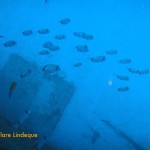
A motley assortment of boats – from a huge yacht to a two metre long rubber duck with a single 15hp motor, as well as some rescue boats, stand up paddle boarders, and kayakers – spent nearly an hour bobbing gently on the mirror-like ocean.
Waiting for the swim to start
A festive atmosphere prevailed. In order to assist their swimmers to identify them, boats were adorned with flags, balloons, inflated papsakke, towels, and other colourful items. Stand up paddle boarders moved through the crowd of boats, and we enjoyed a strange stereo effect when radio announcements were made by the organisers.
A tanker is visible in the distance
Clouds above the calm sea
An assortment of watercraft
The expensive, fancy Robben Island ferry is broken (as it seems to have been almost since the moment it went into service), so Nauticat, the seal watching boat from Hout Bay, is doing duty as one of the ferries bringing visitors to the island until a new ferry is obtained. The ferries practically handbrake turn into the harbour when they arrive, slowing down not at all, so there was a delay at the start of the swim while we waited for a ferry to complete its arrival.
The Robben Island ferry stand-in, Nauticat from Hout Bay, approaches
We could hear the countdown over our VHF radio for the start of the swim for participants wearing swimsuits, and about half an hour later the wetsuit swimmers hit the water. They started inside the harbour, so it was a few minutes before the first swimmer emerged from the harbour entrance and headed for the buoy that marked the start of the course.
Many small craft waiting for the swim to start
Once we had rendezvoused with our three swimmers, we were off! (Swimming happens at a pace close to walking speed, so we trawled along with just one motor at a time.)
Here’s the bow of one of the ferries that travels between Helsingør in Denmark and Helsingborg in Sweden, opening up to expose the ramp that allows drivers to load their vehicles on the vessel in the harbour.
Interestingly enough, it was a lifting bow like this that caused the ferry Estonia to sink, as described in The Outlaw Sea. The Estonia was used in rough seas that she was not designed for, and the mechanism closing her bow and lifting the ramp was faulty. During a voyage in bad sea conditions her bow opened, flooding the interior of the vessel, and she sank very quickly claiming 852 lives.
I didn’t know all this when I took this particular trip! Fortunately the Øresund, the strait between Denmark and Sweden, is very calm.
I took this photograph on a car ferry from Puttgarden in Germany to Rodbyhavn in Denmark, in July 2011. I like the way water looks over the side of a boat.
When we travelled to Denmark in July 2011, we stayed in Helsingør, a small town about 45 kilometres north of Copenhagen. It is the closest town to Sweden, and the Swedish town of Helsingborg lies just a short ferry ride across the Øresund.
It was summer, and the sun stayed up until 2200 or later, so one evening we popped across to Sweden for dinner and a stroll around Helsingborg. On our way into the ferry port at Helsingborg we were able to see a tall ship, the Tre Kronor, leaving.
Tre Kronor leaving Helsingborg, Sweden
The ship had its sails furled, so we couldn’t see how impressive she looks in full sail. The official website for the Tre Kronor is here, and some more photos of the ship here. We had a lovely evening, thank you for asking.
On our way back into the harbour at Helsingør, we saw this swan.
Imagine, a swan in the harbour! I photographed this one in Denmark at Helsingør (Elsinore to English speakers, famous for its castle, where Shakespear’s Hamlet is set) just after getting off the ferry from Sweden.
I first read about the ferry Estonia in The Outlaw Sea, by William Langewiesche. If you haven’t read that book, you should. The Estonia capsized in 1994 in stormy conditions in the Baltic Sea, killing over 850 people.
The official report on the disaster, published by Swedish, Finnish and Estonian authorities in 1997, has always been viewed with skepticism, and conspiracy theories abound. For these reasons Swedish authorities enlisted the Hamburg Ship Model Basin (HSVA), a hydrodynamic research facility, to figure out why the Estonia sank. The researchers used a computer simulation to determine that the sinking of the ferry was a result of the speed she was travelling, the stormy seas, and an attempt made to turn the ferry in order to ride the sea more comfortably.
Car ferry opening up to receive vehicles
The bow visor of the Estonia broke off under the forces experienced that evening from the wind and waves. (The Danish-Swedish ferry shown above has its bow visor lifted to allow cars into the vessel.) The Estonia thus took on water at the bow, and when the crew turned to port, the water sloshed to one side of the ferry and caused a serious list. As the ship tilted, the evacuation routes became mostly impassable (imagine trying to climb a staircase, in the dark, tilted at more than 50 degrees). Only a few of the people on board managed to exit the ship before she sank.
Der Spiegel has an article that explains the disaster and the efforts to pin down its cause, that explains things a lot better than I just have. Read the article here.
William Langewiesche is an American journalist (and pilot). He has written on a variety of subjects. This is the only one of his books I’ve read. I looked for it after reading an excerpt from its first chapter in The Penguin Book of the Ocean.
Langewiesche’s interest here is the wild, unregulated nature of the majority of the planet’s oceans (which, indeed, comprises the majority of the planet, covering 75% of the earth’s surface). Some measure of control – and even this is illusory – may be exercised by governments within their own territorial waters and close to shore. The size and privacy offered by the expanse of waters lying just over the horizon, however, is conducive to unchecked piracy, unregulated shipping activities (near-derelict vessels flying flags of convenience, transporting unexamined cargoes) and an atmosphere of lawlessness reminiscent of America’s Wild West.
Published in 2004, at a time when terrorism was front and centre in the minds of Americans in particular, the book also deals with the possibility of a ship-borne terrorist attack at one of the world’s harbours. The impossibility of scrutinising every container’s contents on the massive container ships that move from harbour to harbour across the globe means that this is a very plausible threat.
Much of the book is taken up with descriptions of vessels foundering, most notably a nondescript cargo vessel called the Kristal and the passenger ferry called the Estonia. These sections are absolutely gripping. Langewiesche’s command of language and ability to explain sequences of events using the testimony of witnesses – whose recollections are coloured by the highly stressful nature of a shipwreck – is supreme. Very little further motivation is required, in addition to these narratives, to convince one of the lawless and unregulated nature of worldwide marine transportation activities.
The final chapter of the book is about Alang, an Indian town in the state of Gujarat that is home to a shipbreaking operation of incredible proportions. Enormous vessels are driven up the beach at high tide, and once lodged on the sand they are systematically stripped and dismantled by thousands of workers. More than half the vessels scrapped worldwide are broken down at Alang. There is almost no regulation of activities there, and there is heavy criticism of the western nations that send derelict vessels across the world to pollute a distant Indian coast, and to sicken underpaid, desperately poor workers with their toxic effluents and fumes. This article and this one describe what happens at Alang. For a visual sense of what Alang is like, you can look at these, these or these photos. Langewiesche’s description of a ship being run aground at Alang is haunting, as is his description of a stripped vessel’s interior as being like a cathedral to modern industry. For an idea of what working conditions are like in these shipbreaking yards, this article has some amazing photographs.
The Outlaw Sea grew out of two articles Langewiesche wrote for The Atlantic. The first one concerns the sinking of the ferry Estonia in the Baltic sea (now chapter four of The Outlaw Sea), and the other deals with shipbreaking in Alang (this particular article is now the sixth and final chapter of The Outlaw Sea). I’d suggest you bookmark both articles and read them; they are fascinating, give a good idea of Langewiesche’s readable and clear style, and will probably make you want to read the remainder of this book.
You can buy a copy here if you’re in South Africa, otherwise here or here.
Here’s a photo of one of the ferries that cross between Helsingor in Denmark and Helsingborg in Sweden. The back door is busy opening in order to let the cars out. The ferry ride is under an hour, and while we were staying in Denmark we popped over to Sweden one evening for dinner.
A short, slightly random video clip I took on the ferry that runs from Cirkewwa in Malta to Gozo. We’d taken the ferry to go and dive the Blue Hole and Inland Sea on Gozo, and on the way back we stood by the rail admiring the magnificent blue of the water beneath us. Malta has no tidal activity and almost no sand close to shore, so the water is ridiculously clear and blue.
Of the ten dives we did in Malta, two were boat dives, done consecutively on one of the days. Our diving companions were all Russian, which meant that Sergey gave us our own personal dive briefing in English, and then switched to more stentorian tones to deliver the Russian version, with the assistance of Peter G. Lemon’s Malta diving book. The first of our boat dives, which were done in such style and comfort that we did not want the day to end, was to the Imperial Eagle, a small ferry that was deliberately scuttled as a diver attraction.
The ship’s wheel is still in place
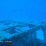
The Imperial Eagle is 45 metres long, 9.2 metres wide, and was 257 tons, powered by two oil engines. She was first launched in 1938 in England. The Imperial Eagle was a car and passenger ferry that could accommodate 70 passengers and 10 cars. Her maiden voyage between Malta and Gozo was in 1958, and she continued on this route for ten years. Afterwards she was used to transport cargo and animals between Gozo and Valletta.
The bow of the Imperial Eagle
The stern of the Imperial Eagle
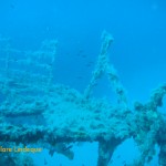
The wreck is slightly broken up in parts
The bow of the Imperial Eagle
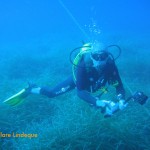
Tony at the wheel
View of the bow from the superstructure
Broken railings
The wheel on the bridge
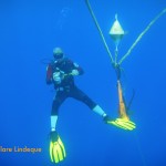
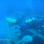
Tony swimming over the wreck
In 1995 she was sold to the local diving community, and was scuttled 500 metres off Qawra Point in 40 metres of water on 19 July 1999. The intention was that the vessel would form the main attraction in an underwater marine park. The vessel is colonised by large numbers of fish, who take shelter around it rather than trying to hide in the exposed, crystal clear waters around the ship.
Divers on the surface after dropping into the water
The propeller and rudder of our diveboat
The ladder for exiting the water
Tony next to the buoy line
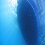
The underside of our dive boat
The visibility was almost top to bottom
Divers above us, doing their safety stop
Knot in the buoy line – not much growing here
Tony – neutrally buoyant
Tony passes over sea grass near the buoy line
We dived the Imperial Eagle off a traditional Maltese boat called a luzzu.Boat diving in Malta is done off a variety of vessels (basically, anything that floats!) but we were very charmed with the colourful hull and spacious accommodations of our boat for the day. Entry into the water was via a giant stride, and to exit one removes one’s fins and climbs up a small ladder on the side of the boat. The boat moves very slowly, and our surface interval was spent driving to L’Ahrax Point, location of our second dive that day.
A traditional Maltese boat, used as a dive boat
One side of the wreck
Saddle bream down the side of the wreck
Tony is surrounded by damselfish as he passes over the wreck
Saddle bream in motion
Saddle bream on the wreck
Storage compartments now open
The wreck is lightly encrusted
Funnel of the Imperial Eagle
The bow of the Imperial Eagle makes her appearance
There is a permanent buoy close to the wreck’s location, and on the way to the wreck one swims past the statue of Christ, located in a natural stone amphitheatre. The wreck is quite deep, and we did notice a distinct set of thermoclines as we descended. Since the coldest of these took us to a water temperature that is more or less the warmest we usually experience in Cape Town (and that usually coupled with Pronutro visibility), we weren’t fussed. Nitrox is an advantage on this site, and we used 32%. The wreck is of a very manageable size to see in a single dive, and is fairly intact but showing signs of her age.