Plaque and Antipolis nameplate at the Twelve Apostles
MV Antipolis ran aground off Oudekraal, along the Cape Peninsula’s western coast, in July 1977. The wreck is visible at low tide, and can be seen from the deck at the nearby Twelve Apostles Hotel – you can admire it while drinking cocktails (or Fanta Grape, if you’re as wild as Tony and me) at the Leopard Bar.
Plaque commemorating wreck of the Antipolis
I was quite surprised to discover the (a?) nameplate of the Antipolis, along with a small plaque commemorating the wreck, on the large terrace adjacent to the Leopard Bar, which I accessed during the course of a very lovely wedding at the hotel. I am sure that if you asked nicely, or moved smoothly like a lizard, you could do the same, even without a wedding invitation in hand. You might be able to crane your neck from the deck of the Leopard Bar, too.
The Man Who Ate His Boots: The Tragic History of the Search for the Northwest Passage – Anthony Brandt
The Man Who Ate His Boots
The Northwest Passage is a sea route (routes, actually) running between Canada and Greenland, across the top of the North American continent through the Canadian Arctic Archipelago, and through the Bering Sea between Alaska and Russia. At its end is the Far East, for hundreds of years the destination of the thousands of sea voyages that made their way around the Cape of Good Hope, and later through the Suez Canal. Its existence was an enormously appealing idea to Europeans, because if the east could be reached by sailing along the top of the world, great savings of sailing time and expense would result.
For a long time the existence of the Northwest Passage was merely a hypothesis, and in the 1800s the British expended vast quantities of energy exploring the Canadian Arctic in search of a sea route. The passage was first traversed in 1850-54 by Robert McClure, by ship and sledge. Roald Amundsen traversed it entirely by ship in 1903-1906. Until this century, the route was not navigable for most of the year owing to the presence of sea ice. Now, thanks (?) to climate change, there is far less ice to contend with.
Sir John Franklin was one of Britain’s most eminent Arctic explorers. He made several trips to the Arctic in search of the Northwest Passage. His final expedition, starting in 1845, ended in the disappearance of his two ships (HMS Erebus and HMS Terror), Franklin himself, and all 128 of the men with him.
The story of his expedition, and the searches for evidence of its fate (upwards of 30 expeditions were mounted to look for him), and the subsequent discovery of what had happened (no spoilers here – it was awful) is related in gripping detail in The Man Who Ate His Boots. Brandt also provides ample historical context, describing prior expeditions which serve to illuminate the British motivations behind their exploration of the Canadian Arctic.
There was a curious mixture of stoic heroism and wild arrogance at work during this period of British history. The rigors endured by early Arctic explorers cannot be overstated – the environment is almost entirely hostile to human survival. The British did not believe that there was anything to be learned from the Inuit, indigenous people who live widely spread across the area, and suffered as a result. As one of the Inuit pointed out when the awful lengths Franklin’s men had gone to in order to try to survive were revealed, his people “know how to starve.”
There is a strong thread throughout this book relating to the colonial attitude towards colonised peoples. A belief prevailed in Britain that, equipped with a shotgun and a good pair of shoes, an Englishman could survive anywhere, and that his Christian piety would serve to protect him and speed his endeavours. (On one of Franklin’s earlier expeditions, which was a complete fiasco largely owing to poor planning, the British officers survived whereas the mixed-race local fur traders – who were doing all the manual work and carrying the supplies – perished. This was attributed to the protective influence of the Christian beliefs of the British men.) It was further reckoned that there was nothing to be gained from studying the techinques of the Inuit. Eyewitness accounts from Inuit turned out to hold the key to the fate of Franklin’s party, although their account was not believed initially (they were dismissed as habitually lying “savages”).
You can read reviews of The Man Who Ate His Boots at the New York Times, Washington Post, and The Guardian. If you enjoyed Endurance, then I recommend you investigate this book. In light of the developing findings of the excavation of HMS Erebus, the material has refreshed relevance today.
Sunday: Boat or shore dives, conditions dependent!
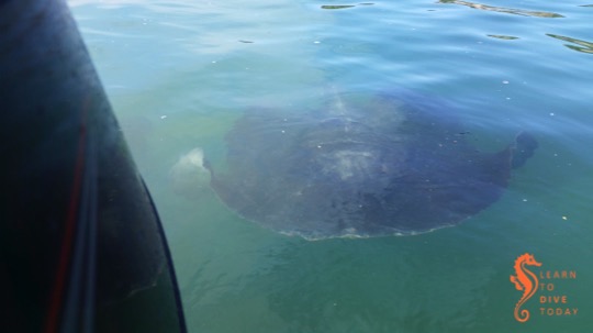
We have had terrific conditions all week and have been taking full advantage. False Bay is cleanish and warmish. Visibility has varied from site to site but the bay is full of life. On Tueday we spent our surface interval time photographing sea swallows at Batsata Maze. Wednesday’s surface interval was spent filming giant short tail sting rays at Millers Point, and today we were fortunate enough to have two orcas swim by close inshore whilst the divers were on the SAS Pietermaritzburg this morning. Who knows what we will see tomorrow!
Giant short tailed sting ray behind the boat at Millers Point
Sadly the diving today was somewhat overshadowed by the raging fire that descended on Simon’s Town with the westerly wind, despite the best efforts of many firefighters. Watching from the water you could see the speed at which the fire traveled and I doubt anything other than a thundershower was going to slow it down. On the run back into Simon’s Town we went through really thick smoke.
Simon’s Town fire
The weekend, however, does not look too rosy. At cowsharks this afternoon the swell was quite noticeable and although it stays at 3 metres for most of tomorrow, the forecast is for 5-6 metres on Saturday. It seldom reaches the height in the forecast but even at 4-5 metres diving becomes less than great. Surge and low viz are on the cards. I think there will be a better than good chance that Sunday will be semi-decent so I will provisionally schedule diving, either from the boat or perhaps a shore dive or two… Text me if you want to join and I’ll keep you posted.
If you’re planning a trip to Cape Town and have a love of shipwrecks on shore, you’re in luck. Visiting some of the wrecks that are visible above the water around the Cape Peninsula can be combined with your exploration of the city, and will ensure that you don’t miss any of its outdoor highlights. Some of these visible shipwrecks can be reached by road, and one or two of them will require a short boat ride.
A map showing all these wrecks can be found here. A mini travel guide to Cape Town’s shipwrecks on shore, in the form of an ebook entitled Cape Town’s Visible Shipwrecks and written by yours truly, is available here.
In addition to the general shipwreck artefacts on display at the museums listed above, you can check out the following specific wreck remains, some of which are not labelled or take a little bit of finding:
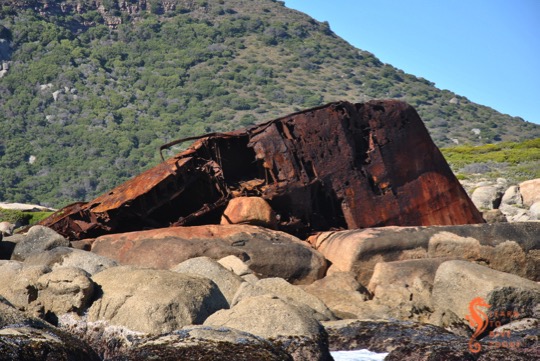
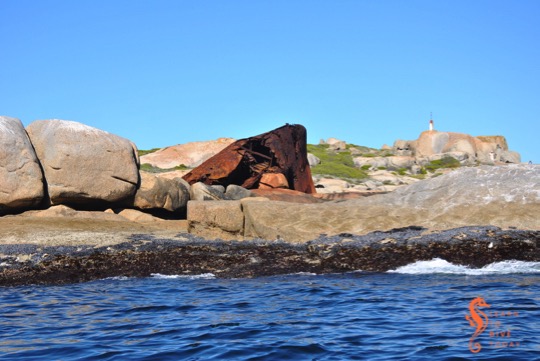
The Antipolis lies against the shore in a small rocky bay
The oil tanker Antipolis ran aground off Oudekraal during a July storm in 1977. She and the Romelia, which is wrecked near Sandy Bay, were both under tow by the tug Kiyo Maru No. 2 from Greece to be scrapped in Taiwan. The wreck lies pointing shoreward, a couple of hundred metres south of the 12 Apostles Hotel. She can be viewed from a vantage point above a storm water drain between the hotel entrance and a small parking area on the opposite (seaward) side of the road. Walk along the Armco barrier from the parking area, looking to your left (while also looking out for cyclists). The storm water pipe is about twenty metres from the parking area and is marked by a gap in the bushes through which the wreck can be seen.
There is also the option of climbing down an impossibly steep and slippery path onto the rocks adjacent to the wreck. The view from here is slightly better, but it is not a climb for the faint hearted.
Bow section of the Antipolis at low tide
View of the Antipolis from the rocks
View of the Antipolis from the road
She is now a beautiful dive site if you visit in clear, calm conditions. Most divers shore dive off the rocky beach in front of the wreck, after climbing over the traffic barrier and walking over the boulders on the shore.
There are some pictures of the tanker just after she grounded here and here (the comments are also worth reading). Her superstructure was cut off some time later for scrap. The entire shape of the wreck can be discerned on aerial images, as much of her lies just below the waterline.
The rocky peninsula at the northern end of Maori Bay, on the opposite side of the bay to the MV BOS 400 crane barge wreck, is called Oude Schip. It can be reached by walking and bouldering from Llandudno, or, as we (predictably) prefer, on a boat ride out of Hout Bay. We are usually in the area with the aim of diving the wrecks of the Maori, the Oakburnor the BOS 400.
High and dry at Oude Schip
On the rocks at Oude Schip are the remains of a Sea Harvest fishing vessel called MFV Harvest Capella. This 44 metre long diesel trawler ran aground in early October 1987, apparently during a south easterly gale. There are some pictures of her aground here and here.
MFV Harvest Capella at Oude Schip
Over the years, part of her bow has been pushed right up onto the rocks by the force of the waves. At the same time it has been breaking up, and perhaps in a few years will be almost indiscernible. The wreckage is quite unstable, and not really suitable for clambering about in any more.
MFV Harvest Capella on the rocks behind our boat
Next time you’re in the area, ask your boat skipper to take you towards the rocks on the Sandy Bay side of Oude Schip to see how the Harvest Capella is looking these days!
Being (in midlife) a creature of the south peninsula, I tend to focus my attentions on False Bay and the Atlantic coast from Hout Bay southwards. But there are rewards for the shipwreck hunter who ventures further north, and even for the shipwreck hunter who doesn’t necessarily want to get their feet wet. A visit to Milnerton beach, and a walk north from Milnerton lighthouse, reveals two shipwrecks in the surf zone. Milnerton beach is surpassingly filthy, but while I was there a beach cleanup was making some headway on the mounds of rubbish tossed off ships in Table Bay that ends up on the beach. The view of the lighthouse from the beach is also far more fetching than the view from the car park, if you can overlook the garbage.
Milnerton lighthouse
About one kilometre north of the lighthouse, where the beach is cleaner and pebbles roll euphoniously in the waves, you will come across the massive boilers of the Hermes in the surf. The NSRI gets calls every year from concerned locals worried that a whale is stranded near the beach; the sea spray sometimes pushes through holes in the top of the wreck creating an illusion of a whale’s blow. The Hermes was a liner, built in 1899, on her way to Cape Town with a large cargo of livestock, forage and a few passengers. When she arrived in May 1901 the harbour was full, and she was forced to drop anchor for the night. A north westerly gale came up, she dragged her anchors, and when the captain ordered her engines started, they failed.
Hermes (front) and Winton (back)
Seawards and to the north of Hermes, the engine block of the Winton is visible, in much the same way as the SS Clan Stuart can be seen at Glencairn in False Bay. The Winton came aground in July 1934, carrying a cargo of wheat from Port Lincoln in Australia to Liverpool, England. Her captain was unfamiliar with Table Bay and had mistook the red lights on top of the radio mast at the Klipheuwel Wireless Telegraph Station near Milnerton for the harbour lights. Attempts were made to pull her off the beach and some of her cargo was salvaged, but the wheat ignited and efforts to refloat her were to no avail.
The visible remains of the Hermes
Hermes (left) and Winton (right)
Hermes in the surf zone
On a calm day, an aerial view of the site reveals the full outline of both vessels surrounding the parts that protrude from the water. When I visited, it was rough after a large swell, but the tide was low. At high tide the view will be considerably less impressive.
The boilers of the Hermes in front of Table Mountain
It is possible to scuba dive this site, and Underwater Explorers dives the Winton every year during their summer Table Bay wreck diving jamboree. Obviously very calm, low swell conditions are required because the wreck is so shallow and so close to the beach.
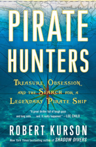
For the days that I spent listening to the Pirate Hunters audiobook on the way to and from work (I have a long commute), I was transported from wintry Cape Town to a sandy bay in the Dominican Republic, to the Archive of the Indies in Seville, Spain, and to the deck of a pirate ship in the seventeenth century.
Friends John Chatterton and John Mattera undertake an obsessive quest to locate a vessel that belonged to the legendary pirate Joseph Bannister. There are accounts of the battle that claimed his ship, but not enough evidence to The life of a treasure hunter may appear romantic from the outside, but in reality it is expensive, monotonous, and frustrating – punctuated with moments of delirious elation. (Treasure – The Search for Atocha also gives an excellent perspective on this irony.)
Robert Kurson is the author of Shadow Divers (gripping), which also features veteran wreck diver John Chatterton as he embarks on a dangerous quest to identify a sunken submarine in the North Atlantic. Unlike Shadow Divers, diving is not as much of the focus in Pirate Hunters. The diving that does take place is in shallow, light-filled tropical water and entails minimal risk to the participants. In both books, however, there is an intense focus on the historical research that is required to positively identify a shipwreck. In Pirate Hunters, Kurson does an excellent job of taking us inside the mind of the pirate Bannister, and it is through a thorough understanding of his motives and character that Chatterton and Mattera make their biggest breakthrough.
Check out the New York Times review of the book, which does highlight some of its shortcomings relative to Shadow Divers. If you’re pirate obsessed or a maritime history buff, however, you’ll enjoy Pirate Hunters regardless.
You can pick up a copy of the book here, if you’re in South Africa, otherwise here or here.
False Bay is clean right now, we had 10-12 m visibility at Atlantis and a little less at Alpha Reef today. A few minutes after the divers rolled into the water at Atlantis a juvenile humpback whale cruised by the bow of the boat, less than 5 metres away. There are signs of a red tide closer to Roman Rock but it was really mild. There were hundreds of compass jellies in the water on both dives. Thanks to Jerrel for this photo from today.
After a good shore dive at Windmill Beach
Last weekend we had a great shore dive at Windmill Beach, and enjoyed seeing so many other divers taking advantage of the excellent conditions. The visibility on Sunday was probably 6-8 metres and the water was a rather chilly 12 degrees.
Dive conditions
The weekend seems to be a one day affair if the current forecast is anything to go by. Saturday looks good with little wind and mild swell. We will launch from Simon’s Town jetty at 9.00 am for SAS Pietermaritzburg and at 11.30 am for Pie Rock.
Sunday and Monday are meant to have more south and south easterly wind than I would like, and boating in that will not be great. I know a number of you guys are keen for a shore dive on Sunday or Monday but we will decide late Saturday on whether we do this or not.
Text or email me if you want to dive on either day, and I will keep you posted.
After our team of relay swimmers completed the Lighthouse Swim, Tony and I made our way back towards Granger Bay via a meandering route that included a search for the buoy marking the Seli 1, off Blouberg beach. We did not find it.
The Seli 1 under Table Mountain
What we did find was quite disturbing: a hissing, pulsating patch of water beneath which the rusty wreckage of the Seli 1 lies, very close to the surface. There was no wind and very little swell when we were searching for the wreck, and initially we thought it was a school of baitfish disturbing the surface in that way. Fortunately we approached the spot slowly, because if we’d ridden over the wreckage this would be a different kind of blog post altogether.
The sea reveals the Seli 1
We rode around the spot as close as we dared, watching the image of the objects below us on the sonar. The buckled plates of the wreck, where the SA Navy divers did their work with explosives to reduce it below the waterline in 2013, were clearly visible. The wreckage – particularly the shallowest part pictured above – is a definite hazard to any boat with a keel. We couldn’t tell exactly how much clearance there is between the top of the shallowest part of the wreck and the surface, but it didn’t seem to be more than half a metre. I hope it’s more than that, and I also hope that SAMSA pays attention to our request for a replacement marker buoy on the wreckage to warn ships (but considering how many channels of communication I had to try before not getting some kind of error, I haven’t a lot of hope).