#CitSciDay2018 at Kirstenbosch

Citizen Science Day 2018 was on Saturday 14 April, and the day was dedicated to a Citizen Science Fair in the conference facilities at Kirstenbosch Gardens. I attended most of the talks, and took a stroll around the expo to see what projects are on offer.

The Citizen Science Fair exhibition hall at Kirstenbosch

I tweeted throughout the day, and have embedded the tweets starting each of my threads below. Click on the tweet (just in the middle, on the white background) to open it on twitter and see the full thread of everything that was shared, or just click on the links in the text preceding each of the three tweets. I included lots of links, so if you want to get more information on any of the citizen science projects in question, half the legwork has been done for you.

Here’s a thread of what took place before teatime:

[tweet 985052929790013441 hide_thread=’false’]

Before lunch this is what happened:

[tweet 985081931070164996]

And after lunch we heard all this!

[tweet 985118792819896325]

Not surprisingly, iNaturalist featured strongly. It’s replaced iSpot, and many of the projects rely on iNaturalist for recording of sightings, and identification. You can create an account for yourself and start contributing to several projects by submitting photographs of what you’ve seen, and tagging them appropriately. Here’s SeaKeys on iNaturalist, and more information on this important project – which is a good place to start as a diver in Cape Town.

Peter & Georgina talking about SeaKeys

We’ve posted before about citizen science opportunities in Cape Town; here’s the info on marine projects, and here is more detail on a few of the terrestrial ones. There’s a LOT going on in this wonderful world, so you can definitely find what interests you!

Monitoring the Oceans from Space MOOC

As your self-appointed education officer and fellow perpetual student, it is my duty to inform you of an upcoming MOOC on the Futurelearn platform, entitled “Monitoring the Oceans from Space“. In the five weeks of the course,  which starts on 24 October, you will learn about using satellite data to monitor the health of the oceans. You will also learn how to access some of the ocean monitoring data that is collected every day about weather phenomena, icebergs, sea levels, ocean temperature, and more. If you’re into creating your own visualisations or crunching numbers yourself, this should appeal.

The course is presented by EUMETSAT and was developed by Imperative Space in partnership with Plymouth Marine Laboratory, the National Oceanography Centre (Southampton), CLS France and NASA JPL.

Read more about the MOOC here, and register here.

Here’s a trailer:

[youtube=”https://www.youtube.com/watch?v=p8hKomGzZ68&w=540″]

Regular service on this blog should resume in the forseeable future; it’s been a heck of a year, so forgive us!

Article: Wired on mapping a sunken aircraft carrier

Wired.com reported on efforts by NOAA to survey and map the USS Independence, a sunken aircraft carrier lying in over 800 metres of water near the Farallon Islands. She was scuttled in 1951 about 50 kilometres off the Californian coast. Wanting to test an underwater autonomous vehicle called the Echo Ranger, the scientists deployed the five ton unmanned mini-submarine from a 25 metre catamaran, and flew her 50 metres above the wreck to take sonar readings.

This kind of technology is fantastic, and will enable the US government to get a better idea of the state all the junk that has been dumped in the region of the Farallons during the 20th century. I imagine a similar survey of parts of False Bay and south of Cape Point (in the areas marked “ammunition dump” on the hydrographic charts) would reveal similarly interesting items…

Read the full article here.

Article: New York Times on the wreck of the Kulluk

We are far enough south that – to me at least – discussions on the subject of oil companies drilling in the Arctic, much of which is now conveniently ice-free in summer, don’t register as viscerally as things that are physically closer to home. But there is a principle at stake here, and a set of risks that corporations have not fully comprehended. The Arctic is a sensitive, valuable ecosystem, and – unlike the populous coast abutting Gulf of Mexico – there are few human settlements and no infrastructure. If something goes wrong with an oil rig or a spill takes place, help is far off and difficult to obtain.

A New York Times article that appeared at the end of last year goes into detail about the consequences of a poorly-planned and executed, premature attempt by Shell to locate oil reserves north of Alaska. The Kulluk was a drill barge, and Shell planned to tow her into the Arcitic so that she could do exploratory drilling for oil.

The emphasis below is mine:

Even with permission, getting to the oil would not be easy. The Alaskan Arctic has no deepwater port. The closest is in the Aleutian Islands at Dutch Harbor, a thousand miles to the south through the Bering Strait. In the Inupiat whaling villages dotting the Chukchi coast, only a handful of airstrips are long enough for anything other than a prop plane. There are few roads; human residents get around in summer by boat, foot or all-terrain vehicle. Shell was trying the logistical equivalent of a mission to the moon. During the short Arctic summer, when the sea ice made its annual retreat, Shell would have to bring not only the Kulluk but everything else: personnel, tankers, icebreakers, worker housing, supply vessels, helicopters, tugboats, spill-cleanup barges and a secondary rig to drill a relief well in case of a blowout. In the wake of Deepwater Horizon, Shell would build a $400 million Arctic-ready containment dome, an extra layer of spill protection that it would also need to drag north.

Predictably, things went badly wrong. The chain of events reads like one of those Reader’s Digest “Drama in Real Life” stories that gripped my sister and me as a child.

Read the full article here.

Article: Wired on giant ocean eddies

Scientists have discovered giant eddies, 100 kilometres across, making their leisurely way across the world’s oceans. The rotational effect extends up to a kilometre below the ocean’s surface. They are quite beautiful when visualised (if you were in one you probably wouldn’t notice – they move very slowly). Wired.com covered this discovery in an article last year.

Read the Wired article here. Bear in mind that the colours in the maps represent height of the ocean surface, not temperature!

If ocean circulation interests you, I cannot recommend Flotsametrics highly enough. You should also check out NASA’s Perpetual Ocean, and their global sea surface temperature and currents map. The Gulf Stream is also quite informative.

Google street view goes to the Antarctic

The ice-obsessed will rejoice with me at this (not at all recent, actually) news: Google has included a number of Antarctic destinations on street view. Destinations include Half Moon Island in the South Shetlands, South Georgia Island, where Sir Ernest Shackleton is buried, Robert Falcon Scott’s hut from his ill-fated 1912 expedition, Shackleton’s hut on Ross Island, an adélie penguin rookery at Cape Royds, the South Pole telescope, the ceremonial south pole, and a couple more on the Antarctic continent.

While we’re down in the Antarctic with Google, they have also provided an interactive map of Shackleton’s Endurance mission of 1914 that gives an excellent idea of the distances covered, and includes both recent and historical photographs.

The Antarctic imagery joins Google’s prior imaging of coral reefs in Australia and a view of the inside a ship.

It’ll be quite a long while (a lot of lottery plays!) before we can afford to go to the Antarctic, and the continent might be much changed by global warming by the time we get there, but in the mean time there’s Google…

Article: Wired on mapping the sea floor to find a plane

It is an oft-repeated bromide that we know more about the surface of the moon than we do about the bottom of the sea. There is some truth in this – in fact, an article at Wired.com states that we know more about Mars than about our own planet’s ocean floor. This deficiency in knowledge was thrown under the spotlight by the loss at sea of Malaysian Airlines flight MH370 in March 2014.

In order to search for the flight in the Indian Ocean, depth survey tracks done in the 1960s (before GPS existed) are being combined with satellite sea floor maps, which are based on measurements of the height of the ocean’s surface from space. The resolution of the satellite data is low – about 20 kilometres, so it was further combined with ship tracks and other publicly available information.

You can read more about the map here, and read the full Wired article here.

Documentary: Ice Patrol

Ice Patrol
Ice Patrol

Ice Patrol is a four part BBC documentary featuring the British naval ice breaking ship HMS Endurance, named for Sir Ernest Shackleton’s polar exploration ship that set sail in 1914. Endurance is much like our SA Agulhas II, except the South African polar research ship is run by the department of fisheries, whereas the British entrust theirs to the navy. The producers of the BBC series Frozen Planet made use of Endurance as a platform for filming in the polar regions – ships with ice breaking capabilities and high tech steering systems are relatively uncommon.

The series starts with Endurance docked in the Falkland Islands, and follows her and her crew through a couple of Antarctic missions during a period of several months in late 2008. They land at South Georgia Island, where Shackleton sought rescue for his crew from Norwegian whalers based there, and visit the old whaling station (as an aside, strangely, we don’t see a single live whale throughout the ship’s time at sea). A group of marines re-enact Shackleton’s trek across the island as a training exercise, which proves to be a tough proposition even with modern camping and climbing equipment, skis, high quality outerwear, and the support of a helicopter for part of the trip. Scientists take sediment cores in order to study climate change, and others conduct an aerial survey of seal populations. We meet a variety of penguins, and members of the crew even pay a visit to a US Antarctic base (Palmer Station) – which has a gift shop!

The final episode is concerned with a catastrophic flood in the engine room that occurred in the Strait of Magellan off Chile (fortunately close enough to help that the civilians on board – the cameramen and producers for the documentary, one assumes – could be airlifted to safety). The ship was nearly lost. The documentary series presents this incident (and other minor whoopsies) in an embarrassingly dramatic light, but it seems that the flooding of Endurance was really that serious. She is going out of service in 2015, the damage she sustained being too costly to repair properly.

After reading Alfred Lansing’s book on Shackleton’s original expedition to the Antarctic, I have been obsessed with the icebound regions of the planet, and this is why we ended up watching Ice Patrol. Perhaps it’s not what everyone would consider gripping television, but we found it very enjoyable. The scenery is beautiful, and the glimpses of shipboard life and navy formality (sitting around on the bridge wearing hats, extreme formality mixed with corporate jargon when addressing one another…) are quite entertaining.

You might be able to get a copy here if you’re in South Africa, otherwise go here.

Video (TED): Paul Snelgrove on the Census of Marine Life

The Census of Marine Life was a ten year global scientifc collaboration intending to find out what has lived, does live, and will live in our oceans. The results of the census were released in 2010, and I have come across two books – Discoveries of the Census of Marine Life and World Ocean Census – documenting some of the discoveries of the census. The Tagging of Pacific Predators (ToPP) program was one part of the census activities. Here, Paul Snelgrove, who was in charge of the team that assembled the findings of the census, shows images of some of the remarkable creatures that were discovered living in the ocean during the course of the census.

[ted id=1372]

On a small scale, the SeaKeys project is a similar initiative confined to South African waters, with a citizen science flavour. If you haven’t already, read about it and get involved!

Scattered shipwreck: The rudder of the Brunswick

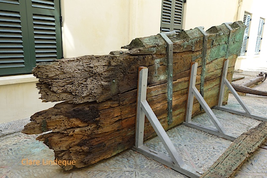
View of the rudder showing the broken end

The Brunswick is an old wooden wreck from 1805 that lies in shallow water just outside Simon’s Town. I’ve taken some video footage on the wreck that also gives you an idea of what it looks like today. When Tony attended a talk on the Brunswick by an Honours student called Jake Harding, who has just completed a project on it, he learned that the rudder from the ship is currently on display in the courtyard of the Slave Lodge in Cape Town.

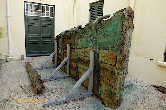
End-on view from the intact end of the rudder


I went to check it out, and it’s awesome! It gives a sense of how large the Brunswick was that I didn’t get from diving her, as the debris is quite low to the sand and much of it is buried.

The rudder of the Brunswick

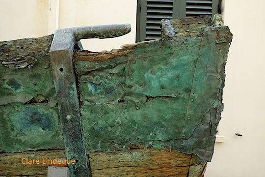
The rudder was salvaged in 1967 by an American salvor, who discovered the copper clad rudder on the wreck site (at that stage unidentified). He required the assistance of the SA Navy to bring the rudder ashore, as it was so large. The rudder then lay on the dock in Simon’s Town for several days, during which time most of its copper cladding was stripped off. Some copper still remains on the rudder today, but it is in very poor condition and has the texture of cardboard – you could probably peel it off with your fingernails, if you were a bad person.

Pintle and copper cladding

The rudder would have been attached to the back of the ship – the stern – onto a part of the vessel called a sternpost (which is what it sounds like). There are hooks (called gudgeons) on the sternpost and pegs (called pintles) on the rudder that enable the rudder to be attached to the ship, and to move from side to side. There are three pintles visible on the rudder at the Slave Lodge, with one of them partly broken off. The rudder measures just over 4 metres by just under 2 metres, and is nearly 30 centimetres thick.

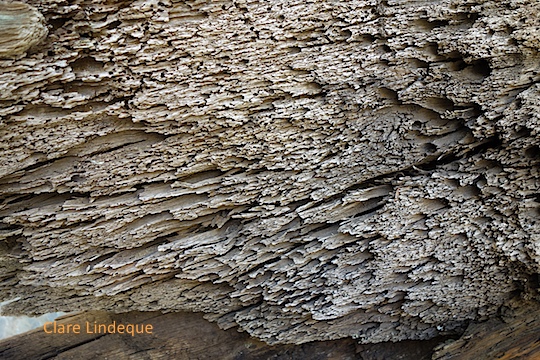
Holes bored by shipworm

One end of the rudder is jagged, and it is believed that originally the rudder was more than five metres long and had another 2-4 pintles. The work of shipworm, Teredo navalis, is evident at the jagged end, where the wood is full of thousands of tiny tunnels created by these creatures. These worms would have lunched on the rudder while it was still attached in the ocean. The cladding of ships’ hulls and rudders with copper was one way to prevent shipworm from damaging the wood while the vessel was still in use, thus prolonging their useful lifespans.

Copper cladding that remains on the rudder

If you’re interested in visible shipwrecks, check out my ebook Cape Town’s Visible Shipwrecks: A Guide for Explorers!