Colour fronts in False Bay

Colour front seen from Sunny Cove on 27 November 2015

Perhaps you have wondered what causes the patterns of strange coloured water in False Bay during the summer months. Perhaps you have dived in it, and wondered why sometimes you can’t see your hand in front of your face! Wonder no more – I am here to help.

Colour fronts

Frequent visitors to and residents of the shores of False Bay will observe that at certain times of the year, the ocean is marked by bands and arcs of sharply contrasting coloured water. This phenomenon is known as a colour front. In oceanography, a front is the interface or boundary between two separate masses of water. In this case, the water masses are easy to discern, because they are of different colours. There are usually other characteristics of the water on each side of the front that differ, too. Fronts are either convergent (the water masses are moving towards each other) or divergent. The presence of marine debris (like pieces of kelp) at the front boundary suggests that it is convergent.

Causes of colour fronts in False Bay

Prior to 2005, there was much conjecture about the causes of these fronts (including the usual pollution bugbear), but little evidence to support any of the theories. By sampling, the fronts were found not to be caused by pollution, or by plankton blooms in the surf zone. It was known that a colour front was most likely to occur in False Bay after a period of southerly or south easterly wind lasting a few days. October and November seem to be prime months for the phenomenon.

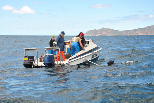
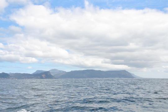
When a large, obvious colour front arose near Simon’s Town in November 2005 with milky green water on one side, and darker blue-green water on the other, researchers from UCT and IMT sprang into action, sampling the water on each side of the boundary so that they could measure its characteristics. Speed is of the essence in these situations; colour fronts can disappear quickly. The one in the picture below is busy decaying – notice the smudged boundary.

Colour front in north western False Bay on 13 November 2014

Measurements revealed that the milky green water overlaid the clearer, bluer water, down to a depth of 11-12 metres (this will vary from front to front). The milky water did not extend to the ocean floor.  Scuba divers around the Cape Peninsula will be familiar with the experience of diving through two or more layers of water, with varying turbidity (clarity) and temperature! (Here is picture of Tony and Christo diving near Oudekraal in the Atlantic that shows what the boundary between two layers of water can look like.)

The researchers found that the milky coloured greenish water was full of fine, almost neutrally buoyant particles of calcium-rich sediment. The green-blue water contained much less calcium, but relatively more silicon, which would suggest the presence of diatoms (a kind of phytoplankton – you can think of them as teeny tiny plant-like organisms) or sand in the water. The origins of the calcium-enriched sediment in the milky water are interesting: one source is from the shallows (less than 30 metres deep) of north western corner of False Bay, where the ocean floor is made up of rocks that are rich in calcium carbonate (such calcrete and limestone), some areas covered by a thin layer of sand.

Milky-white water near Swartklip on 29 November 2014

The second probable origin for the particles of calcium-rich material is the interface between the sea and the land at the northern end of False Bay. The cliffs at Wolfgat/Swartklip at the head of the bay are made of calcrete, and at Swartklip the beach narrows to the extent that the cliffs erode directly into the water when the sea is high. Strong southerly winds create a wide (of the order of one kilometre) surf zone at Muizenberg and Strandfontein; a spring tide also adds to ideal conditions for the generation of a colour front.

The temperature of the milky water was found to be slightly (0.4 degrees Celcius) higher than the green-blue water. This measurement will also vary from front to front. The researchers speculate that the temperature difference could be because the milky water originated in the surf zone, which is shallower and therefore warmer, or because the high concentration of suspended particles in the milky water caused greater absorption of heat from the sun.

Colour front at Smitswinkel Bay on 24 October 2014

Summary

Here’s the tl;dr: strong southerly and/or south easterly winds, perhaps coupled with spring tide conditions, set up a very wide surf zone along the northern end of False Bay, which disturbs the sediment on the ocean bottom and drives the waves further up the beach than usual. Particles of buoyant calcium carbonate from the sea floor and eroded from the cliffs at Swartklip are lifted up into the water column, changing its colour to a milky-green shade. Wind-driven circulation patterns in the bay push the front from its original location in a southerly direction, towards Simon’s Town.

What to do?

Contrary to what your friends on social media may claim, not all colour changes in the ocean around Cape Town can be attributed to a giant sewerage plume. Hardly any of them can, in fact. In summer, the reason for the ocean looking green, red or even brown is likely to do with a plankton bloom of some description, or related to suspended sediments (as in this case) or other naturally arising material in the water. Instead of using this as an opportunity to become hysterical on the internet, how about celebrating the incredibly dynamic system that we can observe, living near the ocean? Drive up a mountain next to the ocean and take in the spectacle from on high. Dip your face in the water and see what it does to the viz. Take some pictures for posterity. And – if you don’t know what’s causing it – try to find and question someone who does know, like a scientist, or consult a good non-fiction book, to find out some facts.

If you’d like to read more about colour fronts in False Bay, take a look at this scientific paper (pdf), which I used as source material for most of this post. The paper is called A Prominent Colour Front in False Bay: Cross-frontal structure, composition and origin

The Phyllisia circuit at Cape Point

Some time ago I promised to describe the route we took in the Cape Point Nature Reserve to locate the wreck of the Phyllisia, a small fishing trawler wrecked in 1968 and one of the visible shipwrecks around the Cape Peninsula. Here’s that post!

The view from the start of the trail at Gifkommetjie

Tami, Maria and I set out on a slightly drizzly, grey morning from the Gifkommetjie parking area inside the reserve. The first part of the walk was a steep descent down to the beach at Gifkommetjie, where we admired some fishing debris. From there, the trail meanders north, parallel to the coast. Most of the path is sandy, but other parts are rocky and hard-packed.

There are natural tunnels formed by the overgrowing milkwood trees, requiring a bit of ducking and crouching to go through. The feeling of being in a forest and yet right by the ocean is lovely. After about 2.5 kilometres – the path gradually bends inland – one reaches a T-junction, with an unambiguous sign saying SHIPWRECK, pointing left. If you want to see the Phyllisia, or just get closer to the coast, take that path!

Turn-off for the Phyllisia

It’s another few hundred metres across unclear paths over the dunes to Hoek van Bobbejaan, a promontory with a beach to the north of it (pictured below) that really shows the wildness of this stretch of coast, and how exposed it is to the open ocean. The Phyllisia is right on the outermost point of Hoek van Bobbejaan, and is the same colour as the rocks it’s lying on, so you might need to look carefully!

The beach at Hoek van Bobbejaan

Just above the wreck is one of the (I think) large okoume logs that fell off a ship in Table Bay in 2008 – more on that in this post about the Shipwreck Trail. It’s a great spot to take stock of your surroundings, and a vantage point for photos, as Maria demonstrates below!

Tami and Maria on the log at Hoek van Bobbejaan

To return, follow the path back towards the T junction and keep going straight. The path forks again – the left fork will take you towards Brightwater, and is part of the overnight Cape Point trail. Take the right fork – you should start climbing the rocky ridge that you’ve been walking alongside, towards the level of the parking area.

The return route is along the top of the ridge, along paths that we sometimes struggled to find because the vegetation had been burned away. Upright sticks with red and yellow paint on the end provided some guidance at intervals. The views down over the path you’ve just walked, and back towards Hoek van Bobbejaan, are spectacular.

You can of course, also return the way you came, and do a short, sharp climb at the end back to the parking area, or do the entire walk back and forth along the ridge, skipping the milkwood tunnels, and descend to the shipwreck half way through the route.

We saw bontebok, ostrich, baboons, an angulate tortoise, and wonderful spring flowers in the dunes and on the mountain. The walk took us about three hours at a slow pace, with a regular photo stops. As always, if you go hiking, go in a group (four really is ideal), wear appropriate shoes and a hat, apply sunscreen take waterproof or windproof clothing even if the weather looks nice, bring water to drink, stay on the path, and tell someone where you’re going and when to expect you back.

If you’re interested in visible shipwrecks, check out my ebook Cape Town’s Visible Shipwrecks: A Guide for Explorers!

Struispunt marine light

Spring flowers at the Struispunt light

Just outside Arniston is the Cape Nature-administered Waenhuiskrans Nature Reserve. The famous Waenhuiskrans sea-cave is actually inside the reserve (which doesn’t appear to be fenced but is indicated with signage). We visited the area and drove into the reserve to the cliffs overlooking Otter Bay, where we had lunch. At the opposite end of Otter Bay to Arniston is Struispunt, which is in fact the eastern extremity of neighbouring Struisbaai.

On Struispunt is a marine light, or beacon, which is essentially a wannabe lighthouse! I walked down the beach to visit it, and back on the sand road behind the beach. The beacon is a masonry tower 10 metres high, topped with a red and white striped globe for daytime navigation and a relatively small, solar-powered light (1,747 candelas) that flashes three times every fifteen seconds. The water off Struispunt is very shallow, only about five metres deep for some distance from the light, so its presence is essential.

Struispunt
Struispunt

The Struispunt light was erected following the wreck of SS Queen of the Thames, in 1871. It is visible for 11 nautical miles. Its western and eastern sides were painted red and white for a while, but most of the paint has worn off and I could only discern a faint reddish tinge. Behind the light, on the rocks, many gulls and cormorants were roosting when I visited. There were also some human fishermen nearby!

Tony took this picture of me walking back from the light

The new Cape Point lighthouse

View of the new Cape Point lighthouse from the sea

To me it would seem totally logical to build a lighthouse as high above sea level as possible. As we saw with the old Cape Point lighthouse, there is such a thing as too high, particularly when you’re building in an area that is prone to heavy mist and fog. The most notable shipping casualty that occurred after construction of the old Cape Point light was that of the Lusitania, wrecked on Bellows Rock in 1911. A new lighthouse was planned, along with a light at Slangkoppunt in Kommetjie, to replace the old light at Cape Point.

View of the new lighthouse at Cape Point

The new lighthouse was built on a 15 metre high pinnacle of rock called Diaz Point, which was dynamited to form a flat platform upon which the lighthouse would be built. Building materials were hauled by oxen from Simon’s Town, and transported by tram down a track on the cliffs. Most of the way the gradient of this tram track was 1 in 4; for a short stretch it was 1 in 2. This is incredibly steep. At the end of the tram track, the building materials were lowered by crane onto a ledge. Building sand was excavated from a cave at the bottom of the cliff, and carried up to the platform on which construction took place. Water was brought close to the building site by trolley, and piped down onto the location.


Like the old lighthouse, the new lighthouse is nine metres high, but instead of cast iron, it is constructed from masonry and the tower is square. The lantern house on top is white. The new lighthouse’s elevation is 87 metres above sea level, giving it a range of visibility of 32 nautical miles. The fully automatic light flashes three times every 30 seconds, and there is a subsidiary red light in the base of the lighthouse facing towards Anvil and Bellows Rock. This light is only visible from the sea, if you go around Cape Point to the western side of Cape Point.

On 11 March 1919 the new lighthouse was commissioned (put into service). The view from this lighthouse covers a full 353 degrees, with seven degrees obscured by Da Gama Peak behind it. It was manned for a time, but is now automated.

Getting closer to the new lighthouse

The public is not allowed to visit the new lighthouse, or even to get particularly close to it. It can be viewed from a viewpoint at the end of the Lighthouse Keeper’s Trail, a highly recommended short walk from the old lighthouse at Cape Point. Along the way you will see the remains of World War II bunkers and a radar station, and you will traverse the most fantastically narrow ridge of rock (in perfect safety). The wind is likely to be extremely strong, whatever time of year you go – dress accordingly. Also note that the walk does not take nearly as long as is suggested by the signage at the start. It is approximately one kilometre each way.

View from the old lighthouse towards the new one

As usual, everything I know about this lighthouse that I didn’t learn by looking at it (i.e. most everything), is thanks to Gerald Hoberman’s wonderful Lighthouses of South Africa book.

Bookshelf: Mountains in the Sea

Mountains in the Sea: A Celebration of Table Mountain National Park – John Yeld & Martine Barker

Mountains in the Sea

Mountains in the Sea is a beautiful coffee table book showcasing the beauty and history of Table Mountain National Park, which stretches the entire length of the Cape Peninsula, in between the urban areas. There is minimal text by veteran environmental journalist John Yeld, and the photographs are from both authors as well as from the archives and other sources.

This is a really gorgeous volume that manages to inform by the choice of images as well as via the text. I have a list of new places I would like to explore after reading it, and half an ambition to do the Hoerikwaggo Trail. It is a wonderful souvenir for visitors, but also an excellent reference for Capetonians who want to get the most out of the natural environment on their doorstep.

You can get a copy of the book here. There is also a pocket-sized volume which has been of great utility to me during my explorations of Table Mountain National Park, but it is harder to find.

A Day on the Bay: Fishing for photos

Clouds over Muizenberg and surrounds

Date: 20 December 2014

We have been following the work of two young photographers, Mac Stone and Joris van Alphen, who were recent recipients of the 2014 Marine Conservation Photography Grant from the Save Our Seas foundation. Both of them arrived in Cape Town early in November last year to commence work on their photojournalism stories: Mac’s is on sharks, and Joris is interested in the reef fishes of False Bay, in particular Red roman.

We felt quite sorry for them – November and December are historically months of appalling visibility and surface conditions in False Bay thanks to the south easterly winds that prevail, and November always seems to play host to at least one massive storm to top things off! Despite having to work with the worst of what False Bay has to offer, the two of them have produced some incredible images, and I’ve admired their persistence and creativity in dealing with murky visibility and adverse surface conditions. (You can follow them on facebook to get regular updates – Mac and Joris.)

Taking pictures at Batsata Maze

Joris was on the boat just before Christmas, getting some of the final set of photographs that he needs for his reef fish story. On this particular trip he wanted to photograph fish on the hook: False Bay is the site of both commercial and recreational fisheries, land and sea-based. Our aim was to track down a Kalk Bay fishing boat that he’d worked with twice already, but they were nowhere to be found (despite being large and yellow, and despite us searching all the way down to Cape Point)! Hailing them on the radio was futile as they likely did not want to broadcast their position.

Working at Batsata Maze

As a consolation prize, Joris and his personal shark spotter Brandon were able to spend time in the water with three recreational fishing boats. The first two were at Batsata Maze/Smits Reef at the southern end of Smitswinkel Bay. The crew of both boats were using handlines to catch roman and hottentot. The sea was quite choppy and working in close quarters to a pitching boat strewn with fishing lines was challenging. The fishermen were very kind and co-operative! Brandon’s presence was necessary because Joris was on the surface, absorbed in his work, next to boats that were hauling twitching fish onboard, and throwing back fish guts and bits of bait (basically chumming). All these things are very interesting to men in grey suits.

The third boat we found fishing with rod and reel on Caravan Reef, the large, shallow reef that lies close by to the south and east of the wreck of the SAS Pietermaritzburg. We were now a bit further north in the bay, and the large swell that we’d experienced at Cape Point and Smitswinkel Bay had been modified and reduced on its path towards Muizenberg. It was calmer in the water, though the visibility was still only 2-3 metres. Joris was looking for split shots, with fish half in and half out of the water, and it seemed to be getting easier.

I had a great day tagging along on the boat, but my interest in the scale and nature of the fisheries in False Bay was piqued, and if I manage to find out anything of interest I’ll share it here. Did you know that both commercial and recreational fishermen visit the reefs that we dive on, and remove the fish that we like to look at? Those in the no-take zones are obviously exempt (apart from the occasional chancer or ignoramus), but we found commercial fishing boats inside Buffels Bay in the Cape Point nature reserve, close to shore. There was a fisheries patrol boat close by, but they were not prevented from fishing there. I found this puzzling and troubling, because when we visited the Cape Point reserve as recreational divers, we had to jump through a variety of bureaucratic hoops just to be allowed to drive a boat through the reserve with dive gear on board! Never mind taking fish out of the water! More to follow on this subject – and perhaps Joris’s story will also help us to understand this issue better.

Tying up at the end of the day

Newsletter: Fog for thought

Hi divers

Weekend diving

Saturday: Shore dive(s)

Sunday: Launching from Simon’s Town jetty for an undisclosed location in False Bay!

Crossing from Robben Island to Big Bay

Conditions report

The weekend started with a foggy wait in Table Bay for the fog to clear before the Robben Island Freedom Swim could get underway. Once it had lifted we were once again treated to a Le Mans style start your engines and full throttle race to Robben Island.There are some pictures on facebook.

We had very clean water for diving in False Bay on Sunday  but the fog made it a little unpleasant on the boat because of the other boat traffic. 

The viz has slowly dropped off during the week. On Monday we were out at Dias Beach inside the Cape Point reserve for another swim event and the water was very clean there and inside False Bay, but by late afternoon it had got a lot darker. Some photos from that day are also on facebook.

Waiting off Dias Beach for the swim to start

The water does not look spectacular anywhere. Hout Bay is not that clean and Table Bay very patchy. False Bay looks better than anywhere else. The downside is that we are forecast to have a southerly swell which does not do False Bay any good. I am at another Robben Island swim event tomorrow so I will have a better idea of the conditions there tomorrow evening.

The diving plan for the weekend is thus shore dives on Saturday, and boat dives in False Bay on Sunday. I’m not going to select sites in advance – we’ll go wherever we can find clean water.

Text or email me if you want to dive.

regards

Tony Lindeque
076 817 1099
www.learntodivetoday.co.za
www.learntodivetoday.co.za/blog/

Diving is addictive!

To subscribe to receive this newsletter by email, use the form on this page!

Newsletter: Submarines in the mist

Hi divers

Weekend diving

Saturday: 8.00 am at OPBC, double tank dives along the Atlantic seaboard

Sunday: To be decided, based on weather and conditions.

Text me or reply to this mail to be kept in the loop, or to book dives.

Submarine in the mist

Volvo Ocean Race

I know that not everyone is a sailing fanatic, but there are currently seven world class racing yachts doing battle in the Atlantic Ocean as the Volvo Ocean Race fleet head for Cape Town. Take a look at the website and facebook page if you are interested. These engineering marvels sailed by some of the world’s best crew are due to arrive in Table Bay between the 2nd and the 6th of November. I am going to be out on the boat in Table Bay with my camera. Text me if you want to be on the list to be notified of this. I have strong ties to Denmark so I am rooting for Team Vestas Wind, but it is a 6487 nautical mile leg – they started in Alicante in Spain – so it’s a long, hard haul and anything can happen.

Conditions report

We dived the wreck of the Maori and the Sentinel on Saturday last weekend and had around 10-12 metre visibility with chilly 9 degree water. Sunday was blown out. The weather this week has been all over the place. On Monday we dived False Bay and had really lousy viz with a grumpy easterly swell. Yesterday we were out on a film shoot project and in thick fog we went around Whittle Rock, down to Rocky Bank and then across to Cape Point. The water was dark brown all the way out to the entrance of False Bay, where it cleaned up a bit, and once back inside the Point the darkness returned. We jumped in at Partridge Point for a brief snorkel with seals in around 2 metre or less visibility.

Fishing at Cape Point

Dive plans

All this means it will be an Atlantic weekend. The winds are forecast to blow somewhere between 10 and 30 knots depending on which forecast you rate the best. The water does not look very clean in Hout Bay or Table Bay today, but the wind tonight and all day tomorrow should fix that.

I will launch from OPBC on Saturday at 8.00 am for a double tank dive and may do a third launch if the conditions are good. The wind is meant to blow harder in the afternoon but we will play it by ear.

I will wait until Saturday afternoon to plan for Sunday once it’s clearer what the conditions will be. If you want to dive, reply to this mail or text me and I’ll keep you in the loop.

regards

Tony Lindeque
076 817 1099
www.learntodivetoday.co.za
www.learntodivetoday.co.za/blog/

Diving is addictive!

To subscribe to receive this newsletter by email, use the form on this page!

Friday photo: Looking east

Looking east towards Simon's Town
Looking east towards Simon’s Town

This is the view from the Muizenberg Shark Spotters hut on Boyes drive, looking over at the eastern side of False Bay. Just above the tree on the right, you can see the huge mark of the Glencairn quarry on the side of the mountain, and Simon’s Town over to the centre and left of the image.

A Day on the Bay: Running in the motors

Date: 6 April 2014

Team Aquaventures on board ready to roll

One Sunday in early April, Tony did a very early launch for an Aquaventures PADI IDC, taking the divers to the wreck of the BOS 400 and to dive with seals at Duiker Island in Hout Bay. You can see in the photo above that the sun hasn’t even reached Maori Bay as the divers kit up! The visibility on the BOS 400 was about six metres, and it was about eight metres at Duiker Island. At the wrecks inside Hout Bay (the Aster and Katsu Maru), there were reports of visibility of up to 15 metres.

After the early launch, Tony and I took the boat for a drive south towards Cape Point. We weren’t in a rush, partly because we needed to run in the boat’s motors gently, and so we stopped to look at the scenery.

Chapmans Peak drive
Chapmans Peak drive

Chapman’s Peak Drive is carved out of the mountainside at the intersection of the Cape granite and sedimentary layers (geologists love this fact), and this can be seen clearly in areas where the mountain isn’t highly vegetated (such in as the photo above). Tony showed me a strange “door in the cliff” – a neat rectangular opening (it seems) that looks like it should be in The Hobbit. You can’t approach it closely on a boat because there’s foul ground in front of it, and the sea is turbulent even when there’s not much swell.

Sea spray on Long Beach, Noordhoek

Long Beach is long. There were lovely big waves, with spray unfurling from their tops in the light breeze. We could see horse riders on the beach, surfers in the swell, and at one point right across False Bay to the Hottentots Holland and Hangklip. Further down, the boiler of the Kakapo shipwreck was clearly visible on the sand.

Idle near a small kelp forest off Long Beach, Kommetjie

Slangkop lighthouse (pardon the blurry photo) is being painted, it seems – the building is completely clad in scaffolding. This was our turning around point, but first we had coffee and a snack. Boating makes you hungry!

Slangkop lighthouse getting a facelift

On the way back we stopped a few times to look around (Tony was looking for a whale shark, after NSRI report from St Helena Bay the previous day, and unconfirmed sightings of one in Kommetjie) and dangle our (ok, my) feet in the freezing water. There was an offshore wind blowing. In places the air was freezing cold, and in others the hot wind, smelling strongly of fynbos, made everything wonderfully pleasant.

We took a drive across the mouth of Hout Bay to Duiker Island, where the water looked quite clean. There were snorkelers in the water with the seals. I drove us back from the island (slowly) – I don’t have a skippers licence yet, and in order to get one I need (supervised) hours on the boat. So this was practice.

Once inside Hout Bay harbour, we milled around a bit waiting for the slipway to clear (some poachers were launching, amongst other activity). We came across the Seal Alert boat, which has sunk into disrepair but is a very enjoyable resting spot for some of the local seals. There are also a few boats that have sunk at their moorings – apparently because their drain plugs were stolen.

The middle (bright green) ship in the picture of the fishing vessels moored in the harbour in the above gallery of images, is the sister ship of a ship that ran aground off Betty’s Bay in February, breaking up and spilling huge amounts of fuel near the vulnerable penguin colony.